 |
|
|
In the United States, states are divided
into counties. Each county is then divided into townships,
and each township into sections.
Click here for more information on the township system.
Knowing or learning which section your ancestors lived can aid
your census record
searches and can also be used with the land records available
from the federal government.
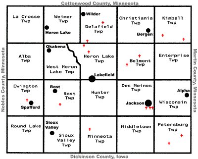
The map below shows the township and town locations for Jackson County
Minnesota.
Clicking on the map will take you to a much larger version you
can use for printing.
The larger
map will show the township numbers as well as the section numbering system.
Google map of Jackson County. Interactive map...use buttons on map to navigate, or click VIEW LARGER MAP
Township maps in Jackson County:
(maps include cemetery locations)- Alba Township Map
- Belmont Township Map
- Christiana Township Map
- Delafield Township Map
- Des Moines Township Map
- Enterprise Township Map
- Ewington Township Map
- Heron Lake Township Map
- Hunter Township Map
- Kimball Township Map
- La Crosse Township Map
- Middletown Township Map
- Minneota Township Map
- Petersburg Township Map
- Rost Township Map
- Round Lake Township Map
- Sioux Valley Township Map
- Weimer Township Map
- West Heron Lake Township Map
- Wisconsin Township Map
County Maps:
- Official MNDOT map of Jackson County
- 1874 plat map of Jackson Co
- 1895 map of Jackson Co provided by 1895 U.S. Atlas
- Entire county map from Tiger Census.gov
- 1911 map of SW Minnesota including Jackson County map
located at Rootsweb genealogy freepages - Minnesota counties map located at MNGenWeb
- MN Counties survey maps, from 1850's
- MN Counties township maps, from 1916
- Minnesota Historical Society, map collection and searches
City Maps (some include township maps):
- Alpha city map, basic map
- Heron Lake city map, basic map
- Jackson city map, map with areas of interest, 2.83mB file size, printable. Or see this basic map
- Lakefield city map, basic map
- Okabena city map, basic map

